Seltannasaggart – Arigna Mountains, Co. Roscommon
Seltannasaggart – the highest point in county Roscommon
I can think of three reasons to visit Seltannasaggart.
- You are hiking the County Tops and therefore need to visit the highest point in Roscommon by taking in the South East slope of this hill.
- You are walking the Arigna Miners Way which passes through the area.
- You work on a wind farm.
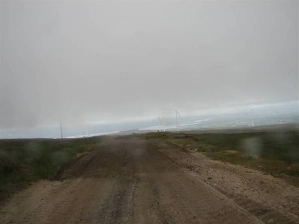
I reached the scarred top of this heavily industrialised hill which is also known as Corrie Mountain by subjecting my car to a rocky access road. It was cloudy and raining. I didn’t linger.
To reach the ‘summit’ and its wind farm you need to drive up into the Arigna hills following signs for the Scenic Drive and then crawl on for about 2 kilometers up the access road, which is unpaved and gave me a healthy dose of puncture anxiety. After passing several junctions where tracks branch off towards the bases of the wind turbine towers, a flat area bounded by piles of sand, wind turbines and machinery is reached. It’s not exactly clear if you are allowed to drive up here as it feels like a construction site. I had the benefit of cloud cover to hide me from the trucks and security vehicles that were dotted around the site.
The summit itself is hard to pick out as the hill-top has been so throughly dug up and levelled by industry. The highest place I could see looked to be on top of a pile of sand. (bearing in mind that I could see about 30 feet in any direction!) I was after the highest point in Roscommon though, which is shy of the summit and lies within a kink in the county boundary line to the South East of the mountain top.
With no views to take in I walked around and admired the wind turbines which were all around me but disappeard into the clouds. Up close they seem both incredibly powerful graceful at the same time. It’s easy to forget that the huge blades are being turned by the wind as they generate electricity, rather than consuming energy to turn themselves.
There’s no clear location for the correct part of the South East slope to mark the highest point in Roscommon, though some folks over on mountainviews.ie have pointed out a rock with a yellow arrow on it as a suitable choice. I found a couple such rocks and retreated to the car to roll down the hill out of the clouds and back to the security of a hard topped road.
Resources for the Arigna Mountains
The Arigna area features the Arigna Miners Way, for which I can’t find much information on the internet. (Note, I’ve since discovered a full route description for Arigna on IrishTrails.ie, which seems to be a decent guide to walking trails throughout Ireland.)
The well-regarded Arigna Miners Experience museum is nearby too and is reported to be well worth a visit.
There are a wealth of megalithic sites including the country’s greatest concentration of sweathouses, which are believed to have been the inspiration for the Scandinavian sauna.
Due to time constraints I didn’t get to visit any of these attractions and as I drove into the clouds shortly after driving up into these hills overlooking Lough Allen I got a minimal impression of the area.
As usual, if you are seeking information on pretty much any mountain in Ireland you’ll most likely find it on Mountainviews.ie.


We ‘the family’ have embarked on the quest to reach the tops and have 11 done. The plan is for a 3 year plus time spell due to young age of youngest.
from your discription and having reasontly been there, did you actually get to the highest point in roscommon or just to the top of the hill which is in another county!
Hi H,
I hope you are enjoying your quest, what mountains have you tackled to date?
I followed the comments of several users of Mountainviews.ie and took a half hour walk or so around the paths and wind turbines near the South East area of the summit of Seltannasaggart, thus satisfying myself that without there being an agreed point I had covered the relevant ground. (Incidentally, the summit appeared to be under a 20 foot pile of sand – so no, I didn’t go to there.)
Of all the county tops I have visited so far this one is the least precise in location, followed closely by Sawel in Co Derry/Tyrone – although at least here there is a fence to hop over.
Best of luck on your quest.
Murray